- Route overview
- The road question: what has changed
- 20-day itinerary
- Thorong La Pass: crossing logistics
- Tilicho Lake: is the side trip worth it
- How difficult is the Annapurna Circuit Trek
- Best time for the Annapurna Circuit Trek
- Annapurna Circuit Trek cost 2026
- Permits and regulations 2026
- Clockwise vs counterclockwise
- Annapurna Circuit vs Everest Base Camp
- Annapurna Circuit vs Manaslu Circuit
- Altitude sickness on the Annapurna Circuit
- What to pack
- Next steps
Over 30,000 trekkers completed the Annapurna Circuit in 2024. That makes it the most-walked high-altitude circuit in Nepal, ahead of Manaslu (12,512) by a factor of 2.5. The total Annapurna Conservation Area saw 246,575 visitors in the first ten months of 2025, a 40 percent surge over the same period in 2024.
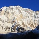
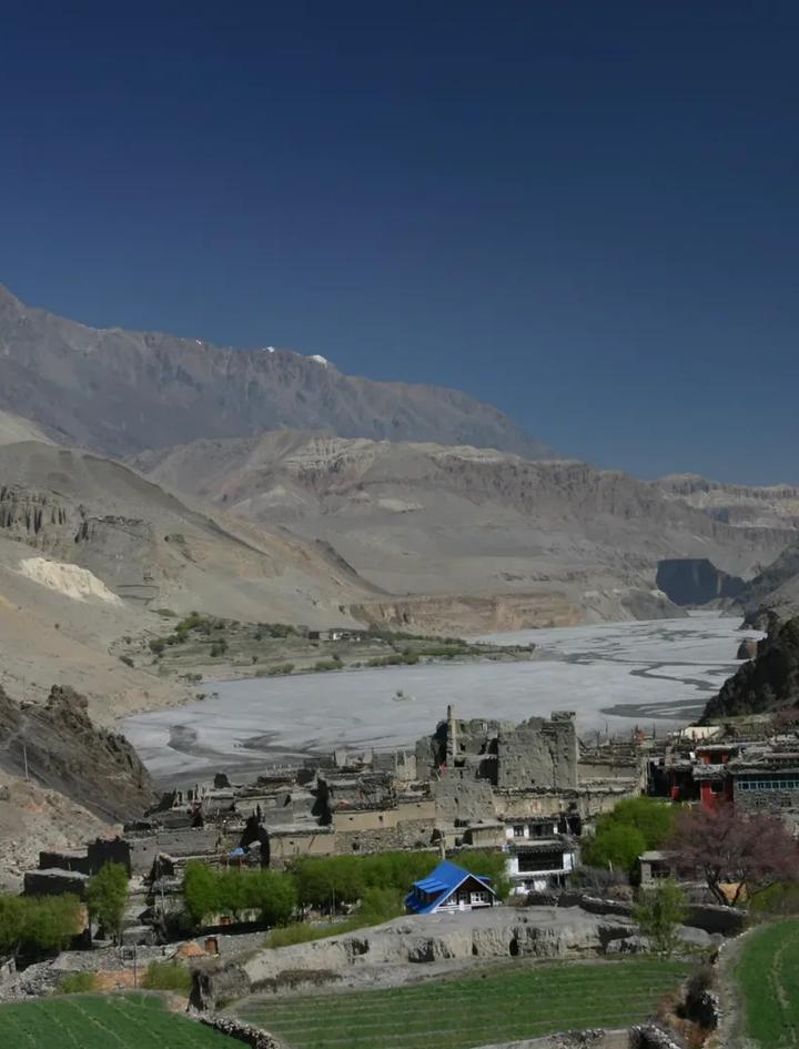
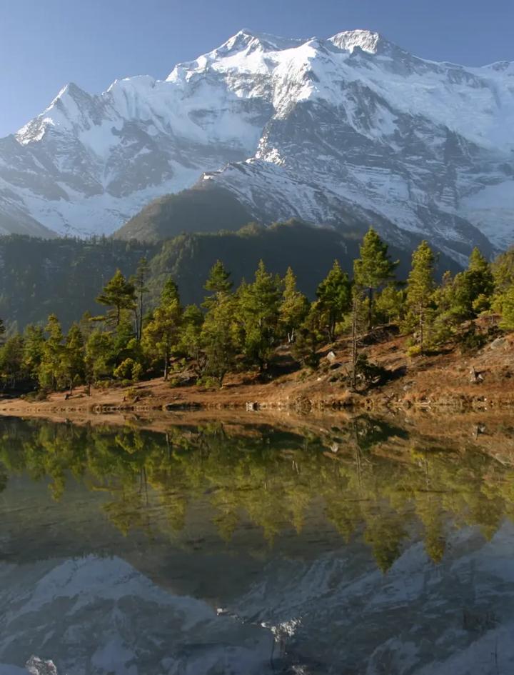
The numbers tell you two things. First, this trek is popular because it earns the traffic. Second, it is not a wilderness walk. The Annapurna Circuit is a well-serviced, teahouse-rich route through some of the most varied terrain in the Himalayas, from rice paddies at 800m to the 5,416m Thorong La Pass to the desert plateau of the Kali Gandaki, the deepest gorge on earth.
There is also the road question. Jeep tracks have replaced trekking trail on the lower section from Besisahar to Chame. This is real and worth addressing honestly. It does not ruin the trek. It changes how you plan it. Mountain Hawk Trek starts the walking from Chamje (1,750m) after a jeep transfer, bypassing the most road-affected section. The upper circuit, where the scenery, culture, and Thorong La crossing happen, is untouched.
This guide covers the full Annapurna Circuit Trek itinerary, the road situation, Thorong La logistics, the Tilicho Lake side trip, costs, permits, and direct comparisons with EBC and Manaslu.
Route overview
The Annapurna Circuit circles the Annapurna massif (8,091m, 10th highest) through four distinct climate zones. You start in subtropical forest, climb through alpine meadows and Tibetan Buddhist villages, cross a 5,416m pass, descend into the arid Mustang plateau, and finish in the lush Kali Gandaki valley. No other single trek in Nepal covers this much geographic range.
Key numbers:
| Fact | Value |
|---|---|
| Total distance | ~160 to 230 km (varies by route and side trips) |
| Duration (MHT) | 20 days (14 trekking + 2 driving + 2 city + 1 rest + 1 departure) |
| Maximum altitude | 5,416m (Thorong La Pass) |
| Highest sleeping altitude | 4,450m (Thorong Phedi) or 4,850m (High Camp) |
| Starting point | Chamje (1,750m), after jeep from Besisahar |
| Exit point | Nayapul, then drive to Pokhara |
| Daily walking | 5 to 7 hours (8 to 10 on pass day) |
| Difficulty | Moderate |
| Guided cost (MHT) | From $1,825 per person |
| Circuit trekkers (2024) | 30,866 |
MHT's 20-day itinerary is more complete than the standard 14-day circuit. It includes the extended western descent through Tatopani (natural hot springs), Ghorepani (Poon Hill sunrise at 3,210m), plus Kathmandu sightseeing and two nights in Pokhara.
The road question: what has changed
Jeep roads now run through sections of the lower Annapurna Circuit. This is the single most discussed change to the route in the past decade. Here is the current status:
| Section | Road status (2026) | Trekking impact |
|---|---|---|
| Besisahar to Chamje | Full jeep road | Dusty, vehicle traffic. MHT bypasses by jeep. |
| Chamje to Dharapani | Partial road, some trail segments | Mixed. Trail alternatives exist. |
| Dharapani to Chame | Road present, parallel trails available | Manageable with guide routing |
| Chame to Upper Pisang | Road extending, trails still primary | Less impacted |
| Upper Pisang to Manang | Mostly trail | Minimal road |
| Manang to Thorong La | No road. Pure trekking trail. | Untouched |
| Thorong La to Muktinath | No road. Pure trail. | The best day of the trek |
| Muktinath to Jomsom | Road exists | Most trekkers end here or take local transport |
| Jomsom to Tatopani/Beni | Full road | Walk or ride, depending on preference |
The bottom line: The road affects the first 2 to 3 walking days on the eastern side. Everything from Chame upward, which is where the Annapurna Circuit becomes the Annapurna Circuit, is trail. Mountain Hawk Trek's itinerary starts with a jeep from Besisahar to Chamje on Day 3, cutting the worst road section out of the route entirely. The upper circuit is the same trek it has always been.
20-day itinerary
| Day | Route | Altitude | Hours | Notes |
|---|---|---|---|---|
| 1 | Arrive Kathmandu | 1,345m | -- | Hotel, gear check |
| 2 | Kathmandu sightseeing | 1,345m | -- | City tour, pre-trip briefing |
| 3 | Drive to Besisahar, jeep to Chamje | 1,750m | 6h drive | Skips road section |
| 4 | Chamje to Dharapani | 1,970m | 7h | Enter Annapurna Conservation Area |
| 5 | Dharapani to Chame | 2,720m | 6h | Pine forests, first Annapurna views |
| 6 | Chame to Pisang | 3,200m | 5h | Upper Pisang route recommended for views |
| 7 | Pisang to Manang | 3,400m | 5h | Tibetan Buddhist territory begins |
| 8 | Acclimatization day in Manang | 3,400m | -- | Day hike to Ice Lake (4,600m) or Braga monastery |
| 9 | Manang to Yak Kharka | 4,000m | 4h | Short day, altitude building |
| 10 | Yak Kharka to Thorong Phedi | 4,450m | 5h | Last teahouse before the pass |
| 11 | Thorong La (5,416m) to Muktinath | 3,800m | 8-10h | Pass day. Start 3:30 AM. |
| 12 | Muktinath to Marpha | 2,610m | 6h | Kali Gandaki valley, apple orchards |
| 13 | Marpha to Ghasa | 1,970m | 7h | Deepest gorge on earth |
| 14 | Ghasa to Tatopani | 1,100m | 5h | Natural hot springs (the name means "hot water") |
| 15 | Rest day in Tatopani | 1,100m | -- | Soak, recover, wash clothes |
| 16 | Tatopani to Ghorepani | 2,850m | 7h | Steep climb, rhododendron forest |
| 17 | Ghorepani to Nayapul, drive to Pokhara | 900m | 5h trek + 1h drive | Optional Poon Hill sunrise (3,210m) at dawn |
| 18 | Pokhara sightseeing | 827m | -- | Phewa Lake, Sarangkot, free day |
| 19 | Drive Pokhara to Kathmandu | 1,345m | 6-7h drive | Tourist bus or optional flight ($100) |
| 20 | Departure | -- | -- | Airport transfer |
Day 8 (Manang acclimatization) is critical. Do not skip it. You are about to climb from 3,400m to 5,416m over the next three days. The Ice Lake hike (4,600m, 4 to 5 hours round trip) is the best acclimatization option and one of the most scenic day hikes on the circuit.
Day 11 is the defining day. Wake at 3:00 AM. Depart by 3:30. The ascent from Thorong Phedi gains 966m to the pass over 4 to 5 hours. Wind builds from the south by late morning and can become dangerous by noon. Cross the pass before 10:00 AM. The descent drops 1,616m to Muktinath, where you arrive exhausted but 1,600m lower and breathing normally again.
Days 14 to 17 (the western descent) are often underrated. Tatopani's hot springs at 1,100m feel miraculous after two weeks above 3,000m. The climb to Ghorepani is tough (1,750m gain) but rewards with the Poon Hill sunrise: a 360-degree panorama of Dhaulagiri (8,167m), Annapurna South, Machapuchare, and the entire Annapurna range.
Thorong La Pass: crossing logistics
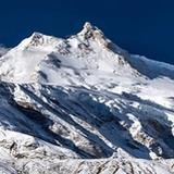
At 5,416m, Thorong La is the highest pass on any standard Nepal circuit and 201m higher than Manaslu's Larkya La.
The night before. You sleep at either Thorong Phedi (4,450m) or High Camp (4,850m). High Camp cuts 400m off the morning ascent but has fewer beds and is colder. In peak season (October), both fill by early afternoon. Pre-booking through your agency is important.
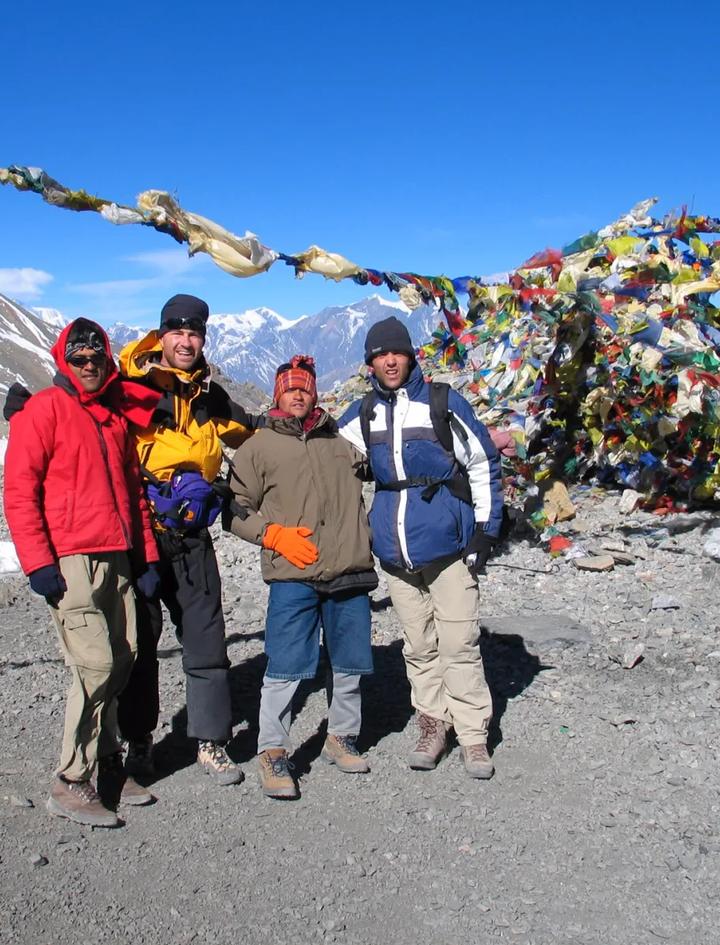
The crossing. 3:00 to 3:30 AM departure. Headlamps required for the first 2 hours. The trail is well-marked with cairns. The oxygen level at 5,416m is roughly 50 percent of sea level. Every step above 5,000m takes effort. The pass itself is a broad saddle with prayer flags and mountain views in every direction. On a clear day, Annapurna II, III, and IV are visible to the south, Dhaulagiri to the west.
The descent. 1,616m drop to Muktinath over 3 to 4 hours on a steep, scree-covered trail. Trekking poles are essential. Microspikes are recommended from October through April when ice patches form on the upper descent.
Weather window. The pass is most reliably clear from late September through mid-November and from late March through May. Heavy snow can close Thorong La from December through February. November 2025 saw an unusual late-season snowfall that temporarily blocked the pass. Your guide checks conditions daily via radio contact with Thorong Phedi lodges.
Tilicho Lake: is the side trip worth it
Tilicho Lake sits at 4,919m, one of the highest lakes in the world. The side trip adds 2 to 3 days to the circuit, branching off from Manang.
| Detail | Value |
|---|---|
| Elevation | 4,919m |
| Side trip duration | 2 to 3 days from Manang |
| Route | Manang to Tilicho Base Camp (4,150m) to Tilicho Lake (4,919m) and return |
| Accommodation | Teahouses now available (no camping required) |
| Difficulty | Strenuous (the trail above base camp is exposed and steep) |
| Best for | Strong trekkers who want an additional high-altitude challenge before Thorong La |
The acclimatization benefit is real. Reaching 4,919m before attempting Thorong La (5,416m) gives your body exposure to near-pass altitudes. Trekkers who do Tilicho first report fewer symptoms on pass day.
The tradeoff: 2 to 3 extra days, additional fatigue, and a demanding trail above Tilicho Base Camp with exposure to scree slopes and potential weather. If you are already comfortable with altitude and want to keep the circuit to 20 days, the Ice Lake day hike from Manang (4,600m) provides similar acclimatization in a single day.
How difficult is the Annapurna Circuit Trek
The Annapurna Circuit is rated Moderate. It is less strenuous day-to-day than the Manaslu Circuit or EBC trek, but longer in total duration.
What makes it moderate, not strenuous:
- Gradual altitude gain. You climb from 1,750m to 5,416m over 8 trekking days, averaging 460m per day. This is gentler than Manaslu's profile.
- Well-maintained trails above Chame. The path is wide, well-marked, and graded.
- Consistent teahouse infrastructure. Meals, beds, and hot showers are available at every stop.
What makes it not easy:
- Duration. Twenty days of travel, 14 of walking. Cumulative fatigue is the hidden challenge.
- Thorong La. One day at 5,416m with a 3:00 AM start and 8 to 10 hours of walking. This is a strenuous day inside a moderate trek.
- The Ghorepani climb. Day 16 gains 1,750m from Tatopani (1,100m) to Ghorepani (2,850m). After 13 days of trekking, this climb is harder than it looks on paper.
Can beginners do the Annapurna Circuit? Yes, with preparation. The Annapurna Circuit is the most beginner-accessible high-pass circuit in Nepal because of its gradual altitude profile and strong teahouse infrastructure. First-time trekkers should be able to hike 6 hours on hilly terrain for consecutive days. An 8-week training program of progressive day hikes with elevation gain will prepare most people. The circuit is not, however, a good first multi-day hike. If you have never spent consecutive nights on a trail, start with Poon Hill (10 days, Easy) or Langtang (11 days, Easy).
Best time for the Annapurna Circuit Trek
| Month | Conditions | Crowds | Pass risk | Verdict |
|---|---|---|---|---|
| January to February | Very cold, short days | Very few | High (snow closure) | Experienced only |
| March | Warming, some haze | Low to moderate | Low | Good spring start |
| April | Rhododendrons in bloom, clear | Moderate | Very low | Excellent |
| May | Warmer, pre-monsoon haze | Moderate | Very low | Good |
| June to August | Monsoon, heavy rain, leeches, landslides | Almost none | Moderate (snow above 5,000m) | Not recommended |
| September | Late monsoon clearing, green | Building | Low | Good from mid-month |
| October | Peak clarity, mild temperatures | Peak | Very low | Best month |
| November | Clear, cold, driest month | High | Low to moderate (late Nov snow) | Excellent |
| December | Cold, shorter days | Low | Moderate | For experienced trekkers |
October and November are the strongest months. Post-monsoon clarity gives 100+ km visibility. Daytime temperatures at Manang (3,400m) sit between 5 to 15C. The pass is reliably open.
April is the best spring month. Rhododendron forests between Ghorepani and Tatopani bloom in full color. Temperatures are warmer than autumn. The tradeoff is occasional afternoon haze reducing long-distance visibility.
Annapurna Circuit Trek cost 2026
| Category | Budget (independent) | Standard (guided) | MHT package |
|---|---|---|---|
| Trek package | Self-arranged | $1,200 to $1,800 | $1,825 |
| ACAP permit | ~$23 | Included | Included |
| Guide (14 days) | $25 to $35/day | Included | Included |
| Kathmandu hotel | Self-arranged | Varies | Included (3 nights, breakfast) |
| Pokhara hotel | Self-arranged | Varies | Included (2 nights) |
| City tour Kathmandu | Self-arranged | Varies | Included |
| Sleeping bag / down jacket | Rent (~$30 total) | Varies | Included (provided) |
| Nepal visa (30 days) | $50 | $50 | $50 |
| Travel insurance | $50 to $150 | $50 to $150 | $50 to $150 |
| Tips (guide + porter) | $100 to $200 | $100 to $200 | $100 to $200 |
| Total estimate | $900 to $1,400 | $1,500 to $2,200 | $2,025 to $2,225 |
MHT's $1,825 package includes all permits, a licensed English-speaking guide, porters, full board meals on the trek, teahouse accommodation, Kathmandu hotel (3 nights with breakfast), Pokhara hotel (2 nights), Kathmandu sightseeing tour, airport transfers, a sleeping bag, down jacket, and duffel bag. Full inclusions list.
On-trail spending. Teahouse rooms run $3 to $5 below 3,000m, $5 to $10 mid-altitude, $8 to $15 near the pass. Hot showers are $1 to $5. WiFi costs $2 to $5 per day. Phone charging runs $1 to $4 above 3,000m. Budget $10 to $15 per day for extras if your package covers meals and rooms.
Pokhara to Kathmandu flight. MHT includes a bus transfer on Day 19. An optional upgrade to a domestic flight costs $100 per person one way (30 minutes vs 6 to 7 hours by road).
Permits and regulations 2026
| Permit | Cost | Status |
|---|---|---|
| ACAP (Annapurna Conservation Area Permit) | NPR 3,000 (~$23) | Required. Checked at entry points. |
| TIMS (Trekkers Information Management System) | NPR 2,000 (~$15) | Not enforced in the Annapurna region as of 2026 |
| Guide requirement | Included in package | Mandatory since April 2023 |
The TIMS confusion. Multiple sources give contradictory information about TIMS card requirements. As of 2026, ACAP checkpoints in the Annapurna region verify the ACAP permit but do not consistently require TIMS documentation. Mountain Hawk Trek includes all necessary permits in every package, removing the ambiguity.
The guide rule. Nepal mandated licensed guides for all conservation area treks from April 1, 2023. Enforcement on the Annapurna Circuit is inconsistent. Some checkpoints verify guide documentation, others check only your ACAP permit. Solo trekkers still complete the circuit without guides. Mountain Hawk Trek includes a guide in every package regardless of enforcement, because a 20-day trek crossing a 5,416m pass is not the place to save money on safety.
Clockwise vs counterclockwise
| Factor | Counterclockwise (standard) | Clockwise |
|---|---|---|
| Direction | East to west (Besisahar to Jomsom) | West to east (Jomsom to Besisahar) |
| Altitude gain profile | Gradual: 1,750m to 5,416m over 8 days | Rapid: 3,760m to 5,416m in 2 to 3 days |
| Acclimatization safety | Better. Slow ascent matches guidelines. | Worse. Fast altitude gain increases AMS risk. |
| Pass day ascent | 966m (from Thorong Phedi) | 1,616m (from Muktinath, much harder) |
| Crowd flow | Walking with 95% of trekkers | Against the flow |
| Teahouse availability | Optimized for this direction | Some teahouses less welcoming to clockwise trekkers |
Go counterclockwise. The acclimatization profile is safer, the pass day is shorter on the ascent side, and the teahouse system is built for this direction. The only argument for clockwise is avoiding crowds in peak October, but altitude sickness risk outweighs any crowd benefit.
Annapurna Circuit vs Everest Base Camp
| Factor | Annapurna Circuit | EBC Trek |
|---|---|---|
| Duration | 20 days (MHT) | 14 days |
| Max altitude | 5,416m (Thorong La) | 5,364m (Everest Base Camp) |
| Cost (MHT) | $1,825 | $1,775 |
| Route type | Circuit (no backtracking) | Out and back |
| Domestic flight | No | Yes (Lukla, $180 to $350 return) |
| Landscape variety | Subtropical to arctic to desert | Mountain valley throughout |
| Cultural zones | Gurung, Thakali, Manang, Mustang | Sherpa throughout |
| Teahouse quality | Good to excellent | Good to excellent |
| Annual trekkers | ~30,000 (circuit) | ~50,000 |
Choose the Annapurna Circuit if you want maximum landscape diversity, prefer a circuit over an out-and-back, or want to avoid the Lukla flight (which cancels regularly due to weather). The circuit gives you more cultural variety and includes the Kali Gandaki gorge and Poon Hill sunrise.
Choose EBC if you want the Everest name and the Khumbu glacier experience, prefer a shorter trek, or are drawn to Sherpa culture. Read the full EBC guide or the EBC vs ABC comparison for more detail.
Annapurna Circuit vs Manaslu Circuit
| Factor | Annapurna Circuit | Manaslu Circuit |
|---|---|---|
| Duration | 20 days | 15 days |
| Max altitude | 5,416m (Thorong La) | 5,215m (Larkya La) |
| Cost (MHT) | $1,825 | $1,675 |
| Restricted area | No | Yes ($100 permit) |
| Trekkers per year | ~30,000 | ~12,500 |
| Teahouse quality | Good to excellent | Basic to moderate |
| Road encroachment | Lower sections affected | Lower gorge only |
| Cultural zone | Mixed Hindu and Buddhist | Tibetan Buddhist (Nubri) |
| Escape routes | Multiple (road access) | Limited (helicopter above Samdo) |
| Side trips | Tilicho Lake, Ice Lake, Poon Hill | Tsum Valley |
Choose the Annapurna Circuit for better infrastructure, more route flexibility, the Thorong La challenge, and the western descent through Tatopani and Ghorepani. Choose Manaslu for fewer trekkers, a stronger sense of remoteness, and Tibetan Buddhist culture. Read the full Manaslu guide.
Altitude sickness on the Annapurna Circuit
The circuit takes you from 1,750m to 5,416m. The critical zone is between Manang (3,400m) and the Thorong La crossing (5,416m), where you gain 2,016m in three trekking days.
Acclimatization strategy:
- Day 8 (Manang rest day) is mandatory. Hike to Ice Lake (4,600m) and return. This exposes you to high altitude while sleeping at 3,400m.
- Above Manang, follow the "climb high, sleep low" principle. The itinerary's gradual ascent (3,400m to 4,000m to 4,450m) matches the recommended 500m per night gain.
- Hydrate 3 to 4 liters per day above 3,500m.
- Diamox: consult your doctor before the trek. Typical prophylactic dose is 125mg twice daily starting 24 hours before ascending above 3,500m.
Warning signs requiring descent: persistent severe headache, vomiting, ataxia (inability to walk straight), confusion, or crackling sounds when breathing (HAPE). Descend immediately. Do not wait for morning.
Evacuation. Helicopter rescue is available from Manang (helipad) and Muktinath. The Annapurna Circuit has more evacuation options than remote treks because of road access below Chame and at Jomsom. Cost: $3,000 to $6,000. Travel insurance with helicopter evacuation coverage is required.
What to pack
Mountain Hawk Trek provides a sleeping bag, down jacket, and duffel bag. Bring the following:
Clothing: Waterproof jacket, hiking pants (2 pairs), thermal base layers (top and bottom), fleece midlayer, wool or synthetic socks (4 to 5 pairs), sun hat, warm beanie, waterproof gloves, insulated gloves for pass day.
Footwear: Waterproof trekking boots (broken in), camp sandals, microspikes for Thorong La.
Gear: Daypack (25 to 35L), trekking poles (essential for the 1,616m descent from Thorong La), headlamp with spare batteries (needed for 3:30 AM pass day start), water bottle (1L minimum), water purification, sunglasses (UV400, Category 3 to 4).
Sun and health: Sunscreen SPF 50+, lip balm with SPF, basic first aid kit, personal medications, Diamox (if prescribed), blister treatment.
Documents: Passport, 2 passport-size photos, travel insurance policy with helicopter coverage, cash in Nepali rupees (ATMs available in Chame and Jomsom but unreliable).
Next steps
The Annapurna Circuit runs year-round with October through November and March through May as the strongest windows. Mountain Hawk Trek handles all permits, logistics, guide arrangements, and hotel bookings for the 20-day circuit at $1,825 per person.
For questions or to discuss dates, contact us or view the full trek details.
If you are comparing routes, read the Manaslu Circuit guide, the EBC complete guide, or the best time to trek in Nepal for a seasonal overview across all regions.