
- What kind of trek this is
- The conservation area around the mountain
- Who lives in the upper valley
- The route, day by day
- Days 1 to 4: Kathmandu to Sekathum
- Days 5 to 7: into the hills and up to Ghunsa
- Day 8: rest at Ghunsa
- Days 9 to 11: Khambachen, Lhonak and Pangpema
- Day 12: a long way down
- Days 13 and 14: the passes
- Day 15: Oktang
- Days 16 to 21: the way out
- Pangpema and Oktang: the north and south base camps
- The mountain behind the base camps
- The three passes on day 14
- How hard the Kanchenjunga trek is
- How the height is spread out
- What to carry
- Permits and the solo rule
- What the Kanchenjunga trek costs
- When to go
- Getting to Taplejung
- Kanchenjunga versus Everest Base Camp and Manaslu
- Who should book it
- Frequently Asked Questions
Kanchenjunga is the third-highest mountain on Earth at 8,586m, and the trek to its foot is one of the most remote in Nepal. Most pages about it talk as though the destination were a single place called base camp. There are two. Pangpema sits on the north side at 5,143m. Oktang sits on the south side at 4,740m. Our trek visits both, and one day of three passes joins them into a circuit.
This guide follows the trek in the order you would walk it: the drives that start it, the climb to Pangpema, the pass day, Oktang, and the way out. After the route come the questions people ask before they book: how hard it is, which permits it needs, whether you can go alone, what it costs and when to go. Every figure comes from our own 21 day itinerary. Where a figure is not settled, I leave it out. The full table of days is on our Kanchenjunga Signature Itinerary page.
What kind of trek this is
The trail begins in the east of Nepal, at a roadhead town called Taplejung, and it takes four days of the schedule to reach the first step. After that the path climbs through farming villages and forest into glacial country, and the walking runs on for two weeks before the roads take over again.
The villages on the way up belong to Limbu and Rai families. Millet grows on terraces cut into the hillsides, the houses are built of bamboo, and tongba, the fermented millet beer, is part of daily village life. Few foreign trekkers pass through. Our tour notes put it at perhaps 200 trekkers a year, and you may not see another group for days at a time.
That emptiness is the appeal, and it is also the risk. The area is restricted, which is why the permit section below matters. It is remote in the plainest sense. Infrastructure is limited above 3,000m, the teahouses are basic, and facilities get simpler again above Tseram. A helicopter evacuation takes longer to arrange here than in the Khumbu or Annapurna regions.
I would not choose this as a first Himalayan trek. The days are long, they stack up, and there is little to fall back on.
The conservation area around the mountain
The trek runs through the Kanchenjunga Conservation Area, in Taplejung District in the far north-east corner of Nepal. It was established in 1997 and covers just over 2,000 square kilometres, which takes in the mountain and four major river valleys. About two thirds of that ground is rock and ice. The rest is forest, shrubland and grassland, and the vegetation steps up from subtropical broadleaf forest through oak and conifers to alpine scrub and meadow. That is the same change from subtropical lowlands to glacial high country that you feel in the first week of walking.
The wildlife list runs longer than most trekkers expect. Snow leopard, Asian black bear and red panda are among the mammals recorded here, more than 300 bird species have been logged, the blood pheasant among them, and more than 800 flowering plants, rhododendron included. In 2012 camera traps caught a leopard cat at 4,474m and a melanistic leopard at 4,300m, which is the height band between your nights at Khambachen and Lhonak. Do not plan on seeing a snow leopard.
Who lives in the upper valley
The lower trail belongs to Limbu and Rai villages, as described above. Ghunsa is different. The people there call themselves Gunsawa and belong to the wider Walung group, Tibetan descendants who speak Ghunsake, a variant of the Walung language, itself part of the Central Tibetan family. Most households grow their own food and graze yaks, and maize and potatoes are the main crops. Until recently many households were semi-nomadic, apart from a few trading families. More young people work in tourism now that the circuit is open.
So the rest day at Ghunsa is also a good moment to notice that the culture has changed since Amjilosa.
The route, day by day
Our trek runs 21 days from Kathmandu back to Kathmandu. The table of every day, with its figures, is on the itinerary page. This section walks the same days in prose.
Days 1 to 4: Kathmandu to Sekathum
You land in Kathmandu at 1,345m. Day 1 is arrival and day 2 is a pre-trip meeting and sightseeing around the valley. On day 3 you fly east and drive to Taplejung, 249km and 8 to 9 hours by road, and the day ends at 1,820m.
Day 4 is another drive, 39km in 5 to 6 hours, to Sekathum at 1,575m. Read that again. The trek starts 245m lower than the town you slept in. It feels wrong to begin a mountain trek by losing height. It is the right start, because everything after Sekathum is up.
Days 5 to 7: into the hills and up to Ghunsa
Day 5 climbs from Sekathum to Amjilosa at 2,380m, a gain of 805m, over 9km and about 6 hours. Day 6 reaches Gyabla at 2,725m after 7km and 5 hours, a gain of 345m. Day 7 is 10km and 5 hours to Ghunsa at 3,415m, which is 690m above Gyabla. In three days you walk 26km, spend 16 hours on your feet and climb 1,840m, from Sekathum to Ghunsa.
The forest does a lot of the work for you here. The rhododendron woods between 2,500m and 3,500m are among the most extensive in Nepal, and in April and May the canopy blooms red, pink and white.
Day 8: rest at Ghunsa
Day 8 has no walking. You stay at Ghunsa, 3,415m, and let the body catch up with the height it has gained. Treat the day as a working part of the plan. The next nights go much higher.
Days 9 to 11: Khambachen, Lhonak and Pangpema
Day 9 is 10km and 6 hours to Khambachen. Day 10 is 10km and 5 hours to Lhonak at 4,792m, the highest night of the whole trek. From Ghunsa that is a gain of 1,377m over two days.
Day 11 is the day the trek is built around. You walk up to Pangpema, the Kanchenjunga north base camp, at 5,143m, and walk back down to sleep at Lhonak again. The climb is 351m, the day takes 7 hours there and back, and you never sleep above Lhonak. The base camp is a day trip from a bed at 4,792m, which makes it gentler than its altitude suggests.
Day 12: a long way down
Day 12 takes you back to Ghunsa in 6 hours. Lhonak is at 4,792m and Ghunsa at 3,415m, so you drop 1,377m in a single day, and trekking poles earn their place on that descent.
Days 13 and 14: the passes
Day 13 is 7 hours from Ghunsa to Sele Le Base Camp, the foot of the first pass. Day 14 is the pass day, covered in its own section below. It ends at Tseram at 3,870m after 7 hours on the trail.
Day 15: Oktang
From Tseram you walk up through Ramche at 4,580m to Oktang, the Kanchenjunga south base camp, at 4,740m, and return to Tseram for the night. The day table prints it as about 8 hours. It is out and back, and the climb from your bed is 870m.
Days 16 to 21: the way out
Day 16 drops to Tortong at 2,995m in about 5 hours, an 875m descent from Tseram. Day 17 is 7 hours to Yamphudin at 2,080m, a further 915m down. Day 18 is another 7 hours to Khebang at 1,915m. Day 19 is a drive to Kanyam, day 20 a drive and a flight back to Kathmandu, and day 21 is departure.
The way out runs through Tortong, Yamphudin and Khebang. It never goes back down past Gyabla and Amjilosa, and that is why the trek counts as a circuit.
Pangpema and Oktang: the north and south base camps
People search for the Kanchenjunga Base Camp as if it were one address. It is not, and the two camps are different days of walking.
| Detail | Pangpema (north) | Oktang (south) |
|---|---|---|
| Altitude | 5,143m | 4,740m |
| Day on our trek | Day 11 | Day 15 |
| Reached from | Lhonak, 4,792m | Tseram, 3,870m, via Ramche, 4,580m |
| Climb on the day | 351m | 870m |
| Day length | 7 hours there and back | about 8 hours there and back |
Pangpema is 403m higher than Oktang, and it is also the easier day on the legs, because the night before is already so high. Oktang is lower on the map and harder on the day, because you start from Tseram and climb nearly 900m before you turn round. Anyone ranking the camps by altitude alone gets the effort the wrong way round.
Pangpema is the end of the trail up from Ghunsa, and it is also spelled Pang Pema. It is the base camp on the north side of the mountain. Our tour notes describe the south camp as a moraine shelf with the Yalung Glacier and the massive south face directly above it. Jannu, at 7,711m, shows to the west once the trail climbs above the trees.
On our schedule the north camp comes first, and the passes then carry you across to the south side.
The mountain behind the base camps
The name comes from Tibetan and is usually translated as the five treasures of the high snow. It fits. Kanchenjunga is a massif with five summits, four of them above 8,000m, on the border between Nepal's Taplejung District and the Indian state of Sikkim. Our trek walks to both of its Nepal-side base camps, so you see the massif from two directions: from Pangpema on the north side, and from Oktang beside the Yalung Glacier on the south.
For a time it was taken to be the highest mountain on Earth. The Great Trigonometrical Survey of India's calculations of 1849 put Everest higher, and in 1856 Kanchenjunga was announced as the third-highest, which it still is at 8,586m.
The glacier you reach on day 15 is where the first ascent began. In May 1955 a British expedition led by Charles Evans climbed from the Yalung Glacier up the Yalung Face. Joe Brown and George Band reached the top on 25 May, and Norman Hardie and Tony Streather followed the next day. The party stopped just below the true summit on purpose. They had promised Tashi Namgyal, the Chogyal of Sikkim, that the top would stay untouched, and with the summit in reach they kept their word. I think that is the best fact about the mountain. It is sacred to communities on both the Nepal and Sikkim sides, few climbers have followed that first party, and the Indian government has banned expeditions from its side.
The three passes on day 14
The trek stops being two out-and-back trips and turns into a circuit on day 14. From Sele Le Base Camp you cross three passes in one day: Sele Le, also spelled Sele La, then Sinion La at 4,440m, then Mirgin La at 4,480m. After Mirgin La the trail drops 610m to Tseram at 3,870m. The whole day is about 7 hours.
Mirgin La is only 40m higher than Sinion La, and that tells you something about the day. You do not climb one big pass. You climb, cross, descend a little, climb again, cross again, and only then come down a long way. The ups and downs look small on a profile and feel large on foot.
Weather changes on this trek, and the pass day is where you feel it most, because there is no village between Sele Le Base Camp and Tseram to stop in.
How hard the Kanchenjunga trek is
Strenuous. That is the grade on our tour page, and I agree with it. The trek reaches 5,143m, the trails are remote, the weather changes, and our tour notes call good fitness and prior trekking experience essential.
The walking days on the day table run from 5 to 7 hours, with the Oktang day at about 8. Our notes ask that you can walk 6 to 7 hours a day on remote trails, and they recommend prior experience above 4,500m. The distances look modest. Days 5, 6, 7, 9 and 10 print at 9km, 7km, 10km, 10km and 10km, which is 46km in 27 hours, under 2km an hour. The pace is slow because the ground is steep and the air is thinning, and a day that covers 10km can still use up your whole afternoon. One hard day is easy to plan for. A long run of them is the real test. If you are building fitness for this, train for long days on your feet with a loaded pack on hills, and do not worry about speed.
How the height is spread out
Altitude is managed by the shape of the route, and you can see it in where you sleep.
| Day | Night | Altitude |
|---|---|---|
| 3 | Taplejung | 1,820m |
| 4 | Sekathum | 1,575m |
| 5 | Amjilosa | 2,380m |
| 6 | Gyabla | 2,725m |
| 7 and 8 | Ghunsa | 3,415m |
| 10 and 11 | Lhonak | 4,792m |
| 12 | Ghunsa | 3,415m |
| 14 and 15 | Tseram | 3,870m |
| 16 | Tortong | 2,995m |
| 17 | Yamphudin | 2,080m |
| 18 | Khebang | 1,915m |
| 19 | Kanyam | 1,630m |
Khambachen on day 9 and Sele Le Base Camp on day 13 are the other two nights.
Ghunsa gets a rest day, and Lhonak gets two nights, one before Pangpema and one after. Pangpema itself is a day trip from a bed at 4,792m, and Oktang a day trip from a bed at 3,870m. You never sleep at either base camp. The highest bed is 351m below Pangpema, and that is a deliberate way to spend a long trek. The risk that remains is the ordinary one: climbing too fast and ignoring a headache. For how altitude sickness develops and what the warning signs look like, see our guide to altitude sickness on the Everest trek, which applies just as well on this side of Nepal.
What makes Kanchenjunga harder than its altitude suggests is the distance from help. A problem that is an hour from a clinic on another trek is a long way from one here, and your guide is the first line of that help.
Travel insurance is compulsory on our trek and it is not in the price, so read the policy for evacuation cover at altitude before you pay for anything else.
What to carry
Pack as if no shop will appear, because none will. Our equipment list asks for waterproof boots, a waterproof jacket, windproof trousers, a sun hat, a beanie, gloves, and sunglasses or goggles with a spare pair. It asks for several pairs of light cotton socks to wear under the wool ones, and the reasoning is fair: better to carry the extra weight than spend the whole time washing socks. It asks for a few pairs of thermal underwear too, because the weather may be cold but you sweat a lot. Take a torch with spare batteries, a sewing kit and a first aid kit, and label your medication.
We lend a down jacket, a four-season sleeping bag and a duffel, and they go back after the trek. One more line from the list is worth repeating. Tight, figure-hugging clothing such as Lycra can offend people in the villages you pass through, especially on women, so wear something loose over it.
If you have done a long trek before, such as the Everest Base Camp trek, you will recognise the rhythm. The difference is that here nobody is ahead of you or behind you.
Permits and the solo rule
Two permits cover the trek. The first is the Kanchenjunga Conservation Area Permit, usually shortened to KCAP. The second is the Kanchenjunga Restricted Area Permit, which exists because the whole region is restricted. Both are included in our price, and the paperwork goes through a registered trekking agency, which for our departures is us.
A licensed guide is mandatory in the restricted area. That is the rule that decides whether you can go alone. Since March 2026 a solo trekker can apply for the restricted area permit individually, where the earlier rules required a group. The guide requirement did not change. So the answer for a solo trekker is yes with a guide and no without one. Independent, guideless trekking is not available here.
Fee amounts change and sources print different figures, so I will not print one here. Our Nepal trekking permits guide keeps the current fee schedule. If you have read about the Manaslu circuit, the logic will be familiar. Our Manaslu restricted area permit guide explains the same kind of permit for a different valley.
What the Kanchenjunga trek costs
Our 21 day Kanchenjunga trek costs USD 2,575 per person, and that number covers more than the walking.
The price covers airport pickup and drop-off by private vehicle, three nights in a two or three-star Kathmandu hotel on twin sharing with breakfast, and a guided city tour. It covers the flight east and back, and every surface transfer from Kathmandu, including the roads to and from Taplejung. It includes the Kanchenjunga Conservation Area Permit and the other permits you need. On the trek you get standard meals and teahouse accommodation, a government-licensed English-speaking guide, and the porters required, with their food, lodging, pay, insurance and equipment. The down jacket, sleeping bag and duffel are lent to you. Government taxes and the tourist service charge are in too. Groups are capped at 8.
Left out are lunch and dinner in Kathmandu, your international flights, the Nepal visa, and travel insurance. Drinks, laundry and other personal items are yours. Tips for the trekking staff and driver are separate, as are sightseeing entrance fees and any personal equipment you need to buy.
For context, one Kathmandu operator's published cost page prices its group package at USD 1,345 to 1,575 per person, falling as the group gets bigger. The same page lists a one-way domestic flight at about USD 140, a guide at USD 30 to 35 a day, a porter at USD 25 a day, a private jeep for the road to Taplejung at USD 250 to 300, and teahouse beds at USD 5 to 15 a night. It puts a whole trek at USD 1,500 to 3,000 per person for 18 to 25 days, and it lists porter services among the package exclusions.
I read that spread as a question about what sits inside each number. A price that leaves out porters, the flight or the Kathmandu nights looks lower on the page and rises by the end. So check four things in any quote: whether it includes the flight and the roads to Taplejung, whether porters are in the price, whether it covers the permits, and how big the group is. That page shows its own price dropping as the group grows.
When to go
October to November is the time for clear views. April to May brings the rhododendron blooms and warmer weather. If you want the forests in flower, go in spring. If you want the mountains standing clear, go in autumn.
The monsoon makes the lower trail very wet, and that is where the first days of walking happen. Winter is extremely cold above 4,000m, which covers Lhonak, Pangpema and the pass day.
The windows are wide enough that your own calendar usually decides. Our month-by-month season calendar for this trek covers each month in detail, from the cold at Lhonak to the snow risk on the passes. For the wider picture across Nepal, see our guide to the best time to trek in Nepal.
Getting to Taplejung
Everything about this trek begins with a road. You can fly from Kathmandu to the lowlands of eastern Nepal and drive on, or drive the whole way from Kathmandu, which takes 18 hours or more. We arrange the logistics, and for most people the flight is the sensible choice.
On our schedule the flight and drive take day 3, with 249km and 8 to 9 hours of road ending in Taplejung at 1,820m. Day 4 is a 39km drive of 5 to 6 hours to Sekathum at 1,575m, where the walking starts. Two days of driving before the first step of the trek is a lot. It is one reason this trek stays quiet.
Kanchenjunga versus Everest Base Camp and Manaslu
Our Everest trek runs 15 days and reaches 5,545m, with teahouses along the way and hundreds of trekkers on the trail each day. Kanchenjunga runs 21 days and reaches 5,143m, which is 402m lower, on a remote and basic trail. The mountain at the end is the third-highest in the world, and the country around it is wilder than the one at the foot of the highest. The Everest trek has the bigger single number. Kanchenjunga asks for the longer commitment. Our Everest Base Camp difficulty guide covers the other side of that comparison.
Manaslu is the closer match. Both are restricted-area circuits that need a permit and a licensed guide, and both suit a trekker who prefers quiet trails to busy ones. Our Manaslu circuit guide lays out that trek. Kanchenjunga is further east, the road to the start is longer, and the trail is quieter again.
If you want the whole region instead of one trek, our Makalu and Kanchenjunga region page lists what else we run in the east.
Who should book it
This trek suits you if you want to reach the foot of the world's third-highest mountain in real wilderness. You can walk 6 to 7 hours a day on remote trails. You are comfortable with basic teahouses, with facilities that get simpler above Tseram. You have been above 4,500m before, and you have 21 days free.
It does not suit a first-time trekker, someone who needs a clinic within an hour, or anyone who wants company on the trail. Groups are capped at 8, and on a trail where you may not see another group for days, the people you walk with matter more than they would on a busier route.
If that sounds like you, the next step is our Kanchenjunga Base Camp trek page, where you can see departures and ask us about the route.
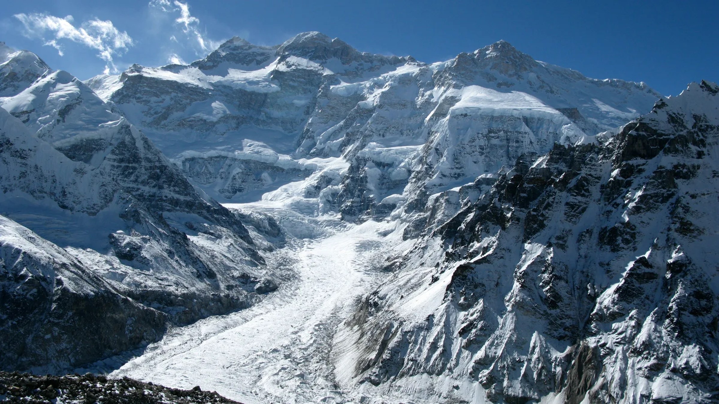
Cover photograph: Kangchenjunga's north face from Pangpema, by Tomabarker on Wikimedia Commons, licensed CC BY 3.0.
Frequently Asked Questions
How many days does the Kanchenjunga trek take?
Our trek is 21 days from Kathmandu to Kathmandu. That includes a rest day at Ghunsa and visits to both the north and south base camps.
Which Kanchenjunga base camp is higher?
Pangpema, on the north side, is at 5,143m. Oktang, on the south side, is at 4,740m, so the north camp is 403m higher.
Can I walk Kanchenjunga on my own?
Since March 2026 a solo trekker can apply for the restricted area permit individually. A licensed guide is still mandatory, so you walk with a guide.
When is the best season for Kanchenjunga?
October and November bring the clearest views. April and May bring rhododendron blooms and warmer weather. The monsoon leaves the lower trail very wet and winter is extremely cold above 4,000m.
How isolated is the Kanchenjunga route?
Very. It runs through far-eastern Nepal with limited infrastructure above 3,000m, basic teahouses, and helicopter evacuation that takes longer than in the Khumbu or Annapurna regions.